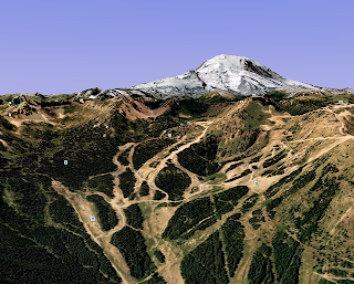
This weekend I spent an absolutely inordinate amount of time on Google Earth. I'm not just talking about the Google Maps online, but the Earth application that you can download from Google. What's cool about this program is that you can freely zoom around the world in 3D . It maps photographic satellite imagery onto a 3D rendering of the earth's topography, allowing for a really detailed and thorough exploration of just about anywhere. The program has a lot of powerful and cool features, including a flight simulator. I was completely absorbed in this thing for hours. But why was it more fascinating to me than just a video game? Because it enabled me to explore the real world. I had the whole globe at my fingertips. I could go anywhere in mere seconds. I explored not only exotic places like the mountains of Hawaii and Nepal, but more familiar places where I lived or went on excursions. It was an entirely digital, online experience but it connected me with the real world.
I realized that Google Earth fills in a huge gap between the real world and the digital world. One of the most interesting features is that there are little photo icons scattered across the landscape. When you click on one of them, it displays a user-uploaded photo that was taken at that location and hosted at panoramio.com, a social photo-sharing site. This feature adds so much depth to the experience and more thoroughly connects this digital world with the real world. On Google Earth, I found a small canyon near Moab that I explored last month, and seeing that there were no photos of it, I immediately signed up on Panoramio to upload the photos I took there and put them on the map. It was exiting to think about being a part of this online, collaborative documentation of the earth. I guess this makes the way we look at the digital world a lot closer to how we look at the real world.

I saw you looking at Google EArth, and now you've got me hooked. I downloaded it and now I'm an addict.
ReplyDelete